Approximate Location Map
Large Map »
Latitude: 53.4012 / 53°24'4"N
Longitude: -1.5353 / 1°32'7"W
OS Eastings: 430993
OS Northings: 389478
OS Grid: SK309894
Mapcode National: GBR 91B.8K
Mapcode Global: WHCCB.DR4X
Plus Code: 9C5WCF27+FV
Entry Name: River Dale House and River Dale Cottages
Listing Date: 12 January 2000
Last Amended: 17 February 2000
Grade: II
Source: Historic England
Source ID: 1379967
English Heritage Legacy ID: 479435
ID on this website: 101379967
Location: Wisewood, Sheffield, South Yorkshire, S6
County: Sheffield
Civil Parish: Bradfield
Traditional County: Yorkshire
Lieutenancy Area (Ceremonial County): South Yorkshire
Church of England Parish: Wadsley
Church of England Diocese: Sheffield
Tagged with: Cottage
SK 38 NW BRADFIELD LOW MATLOCK LANE
564/14/10012 River Dale House and River
Dale Cottages
12.1.2000
GV II
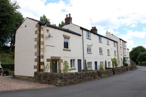
Terrace of houses with attached outbuilding. c1800 or earlier, with mid-late C19 and early C20 alterations. Coursed rubble sandstone, rendered on the front elevation, with brick ridge and gable stacks and Welsh slate roof coverings. Linear stepped range, aligned east-west, with 2 storeyed stable with overloft to west end, and taller advanced dwelling to east end. FRONT (south) ELEVATION: 2 storeys with attics, 8 bay range with 2 double-fronted houses to centre of range with a taller house to the east end with doorway to left side and canted bay window to right. Coupled sash windows without glazing bars above canted bay, single sashes to both floors above door. 3 light casement windows to centre houses, with square bay window with sashes to right of door of right-hand house. Former stable to west end with quoined corner, massive surround with bonding stones to main doorway and taking-in door above. INTERIORS: East end house with interior remodelled c1900, including contemporary hearth surround, doors and panelling. The 2 other dwellings are plainly detailed with simple hearth surrounds and central dog-leg stairs. HISTORY: The houses provided accommodation for workers and the site manager of the nearby water-powered rolling mill which was destroyed by the Sheffield Flood of 1864, when a reservoir dam at the head of the Loxley Valley failed. The River Dale House and River Dale Cottages, which formed part of a small industrial hamlet at Low Matlock survived the catastrophe, being sited on higher ground. A terrace of early C19 houses forming part of the setting of Low Matlock Rolling Mill (item 14/48) and a significant component of a small rural industrial community in the Loxley Valley, an important location representative of the development of Sheffield's water- powered metal working industries in the C19.
Listing NGR: SK3099389478
External links are from the relevant listing authority and, where applicable, Wikidata. Wikidata IDs may be related buildings as well as this specific building. If you want to add or update a link, you will need to do so by editing the Wikidata entry.


Other nearby listed buildings
