Approximate Location Map
Large Map »
Latitude: 50.5396 / 50°32'22"N
Longitude: -2.4281 / 2°25'41"W
OS Eastings: 369757
OS Northings: 71175
OS Grid: SY697711
Mapcode National: GBR PZ.44CL
Mapcode Global: FRA 57SM.ZV4
Plus Code: 9C2VGHQC+RQ
Entry Name: Rufus Castle with Bridge
Listing Date: 16 January 1951
Last Amended: 17 May 1993
Grade: I
Source: Historic England
Source ID: 1280727
English Heritage Legacy ID: 381924
ID on this website: 101280727
Location: Easton, Dorset, DT5
County: Dorset
Civil Parish: Portland
Built-Up Area: Weston
Traditional County: Dorset
Lieutenancy Area (Ceremonial County): Dorset
Church of England Parish: Portland All Saints
Church of England Diocese: Salisbury
Tagged with: Castle
PORTLAND
SY6871 CHURCH OPE ROAD, Easton
969-1/4/32 (South side)
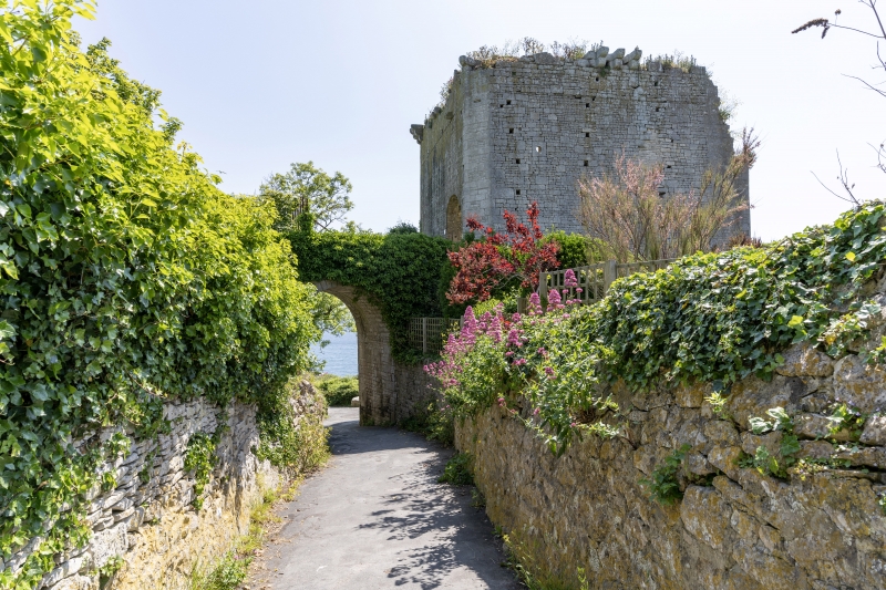
16/01/51 Rufus Castle with bridge
I
Formerly known as: Bow and Arrow Castle CHURCH OPE ROAD.
Castle. Present structure probably late C15, on site of
earlier building captured in 1142 by Earl Robert of
Gloucester. The approach bridge and present entry archway are
C19, and were already here in 1842. Squared and snecked
Portland stone, unroofed. An irregular pentagon with remains
of an outer bailey contained by remaining section of wall to
SW; connected by lofty C19 round-arched bridge to high land
across Church Ope Road, to the north. Remaining keep has C19
round-arched entry across this bridge; walls have many
regularly-spaced putlog holes. The 'Tudor' arched entry to the
SW was inserted by John Penn, of the adjacent Pennsylvania
Castle. There are a few remaining stones of the former
machicolation on the W and N walls, and the walls generally
run to full height, but some of the SE wall has fallen away.
The N and W walls also have series of round gun-ports, with
embrasures behind. RCHM notes chamfered stone jamb of SE
doorway. The outer bailey wall follows the land slope, and is
from c 1m to c 1.5m high, to rounded coping.
(Royal Commission on Historical Monuments: Dorset: London:
1970-: 252-4; Buildings of England: Pevsner N and Newman J:
Dorset: London: 1972-1989: 342).
Listing NGR: SY6975771175
External links are from the relevant listing authority and, where applicable, Wikidata. Wikidata IDs may be related buildings as well as this specific building. If you want to add or update a link, you will need to do so by editing the Wikidata entry.


Other nearby listed buildings
