Approximate Location Map
Large Map »
Latitude: 52.0553 / 52°3'19"N
Longitude: -2.7161 / 2°42'57"W
OS Eastings: 350996
OS Northings: 239904
OS Grid: SO509399
Mapcode National: GBR FL.DLWX
Mapcode Global: VH85N.VLZQ
Plus Code: 9C4V374M+4H
Entry Name: 19A, Church Street
Listing Date: 27 July 1994
Grade: II
Source: Historic England
Source ID: 1196816
English Heritage Legacy ID: 372306
ID on this website: 101196816
Location: Hereford, County of Herefordshire, HR1
County: County of Herefordshire
Civil Parish: Hereford
Built-Up Area: Hereford
Traditional County: Herefordshire
Lieutenancy Area (Ceremonial County): Herefordshire
Church of England Parish: St Peter with St Owen and St James, Hereford
Church of England Diocese: Hereford
Tagged with: Building
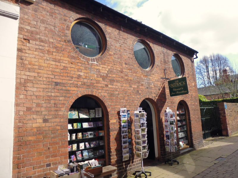
HEREFORD
SO5039NE CHURCH STREET
683-1/2/128 (North West side)
No.19A
GV II
Coach house, stable and loft, now shop. Early C19. Brick;
pantile roof. 3 circular openings, 2 with plank shutters, the
central blocked; brick modillion eaves. Blind arcading with
semicircular arches, to ground floor. Restored 1991.
Listing NGR: SO5099639904
External links are from the relevant listing authority and, where applicable, Wikidata. Wikidata IDs may be related buildings as well as this specific building. If you want to add or update a link, you will need to do so by editing the Wikidata entry.


Other nearby listed buildings
