Approximate Location Map
Large Map »
Latitude: 51.5789 / 51°34'43"N
Longitude: -2.5775 / 2°34'39"W
OS Eastings: 360076
OS Northings: 186823
OS Grid: ST600868
Mapcode National: GBR JR.CNCY
Mapcode Global: VH882.8LQ0
Plus Code: 9C3VHCHC+GX
Entry Name: Green Farmhouse
Listing Date: 5 December 1984
Grade: II
Source: Historic England
Source ID: 1136963
English Heritage Legacy ID: 35295
ID on this website: 101136963
Location: Olveston, South Gloucestershire, BS35
County: South Gloucestershire
Civil Parish: Olveston
Built-Up Area: Olveston
Traditional County: Gloucestershire
Lieutenancy Area (Ceremonial County): Gloucestershire
Church of England Parish: Olveston
Church of England Diocese: Bristol
Tagged with: Farmhouse
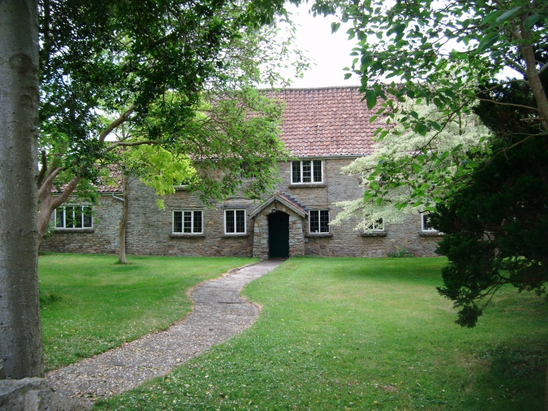
ST 68 NW OLVESTON THE GREEN (south side) Olveston
8/186 Green Farmhouse
- II
Farmhouse, now house. C15 origin with later alterations and additions.
Rubble, pantiled roof with brick gable stacks. L-plan, former open hall house.
2 storeys and 3 windows, all 2 and 3-light casements with leaded lights except
1st floor 2nd from left, unglazed window with wooden mullions, square set and
chamfered with step stops and timber lintel, ground floor windows have timber
lintels, 3rd bay from left has C20 gabled porch, slits to each side and plank
door in wooden frame, timbers in wall above 2nd window from left and to right at
ground floor, single storey wing to left has 4-light casement with timber
lintel; west elevation has 2-light casement with timber lintel at 1st floor
left, all other windows C20, 2 storey wing to right. Rear has central dormer
extension, 3-light casement at ground and 1st floor right, door and 2 C20
windows, east side of rear wing has door with timber lintel, 4-light casement at
ground floor and 3-light at 1st floor. Interior: chamfered and stopped beams
and fireplace lintel, blocked fireplace in west room has large stone lintel,
door to former hall from kitchen has cut back frame on one side for passage of
barrels; roof smoke-blackened at west end, 5 collar-beam trusses, 2 and 4
having cambered collars, central truss has arch-braced collar, 2 pairs of butt
purlins, in 2 central bays 2 tiers of windbraces, diagonal ridge. Rear kitchen
wing probably added late C17/early C18. (Sources: Hall, Linda : Rural Houses
of North Avon and South Gloucestershire, 1400-1720. 1983).
Listing NGR: ST6007686823
External links are from the relevant listing authority and, where applicable, Wikidata. Wikidata IDs may be related buildings as well as this specific building. If you want to add or update a link, you will need to do so by editing the Wikidata entry.


Other nearby listed buildings
