Approximate Location Map
Large Map »
Latitude: 51.3795 / 51°22'46"N
Longitude: 0.2233 / 0°13'23"E
OS Eastings: 554824
OS Northings: 166844
OS Grid: TQ548668
Mapcode National: GBR VM.T4C
Mapcode Global: VHHP6.TLF9
Plus Code: 9F3296HF+R8
Entry Name: 46 and 47, High Street
Listing Date: 1 June 1967
Grade: II
Source: Historic England
Source ID: 1237798
English Heritage Legacy ID: 415093
ID on this website: 101237798
Location: Farningham, Sevenoaks, Kent, DA4
County: Kent
District: Sevenoaks
Civil Parish: Farningham
Built-Up Area: Eynsford
Traditional County: Kent
Lieutenancy Area (Ceremonial County): Kent
Church of England Parish: Farningham St Peter and St Paul
Church of England Diocese: Rochester
Tagged with: Building
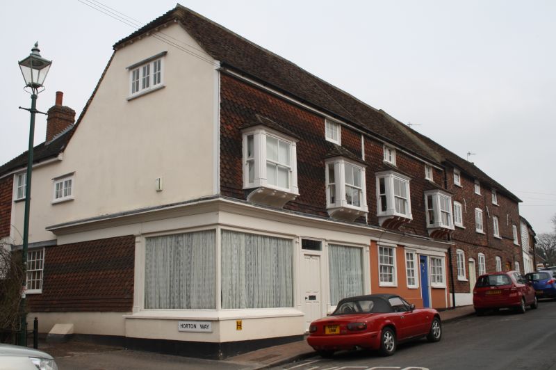
FARNINGHAM HIGH STREET
1.
5280
(north-east side)
TQ 5466 10/106 1.6.67 Nos 46 and 47
II
GV
2.
Early C19. Three storeys, the ground floor stuccoed, the upper floors hung with
curved tiles. Tiled roof. Three small sashes to top floor, 4 bays to first floor.
No 46 has a C19 shop front with pilasters. No 47 has 2 sashes and a door with
4 flush panels.
Listing NGR: TQ5482666843
External links are from the relevant listing authority and, where applicable, Wikidata. Wikidata IDs may be related buildings as well as this specific building. If you want to add or update a link, you will need to do so by editing the Wikidata entry.


Other nearby listed buildings
