Approximate Location Map
Large Map »
Latitude: 51.9941 / 51°59'38"N
Longitude: -4.9763 / 4°58'34"W
OS Eastings: 195762
OS Northings: 237032
OS Grid: SM957370
Mapcode National: GBR CK.JJBQ
Mapcode Global: VH1QM.P4LN
Plus Code: 9C3QX2VF+JF
Entry Name: The Royal Oak
Listing Date: 24 November 1978
Last Amended: 7 January 2002
Grade: II
Source: Cadw
Source ID: 12321
Building Class: Commercial
Also known as: The Royal Oak, Fishguard
Royal Oak
ID on this website: 300012321
Location: Situated on the north side of the square, between the War Memorial and Barclays Bank.
County: Pembrokeshire
Town: Fishguard
Community: Fishguard and Goodwick (Abergwaun ac Wdig)
Community: Fishguard and Goodwick
Locality: Fishguard
Built-Up Area: Fishguard
Traditional County: Pembrokeshire
Tagged with: Pub
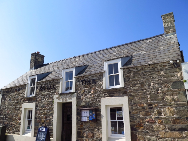
C18 house, now an inn very similar in style to the Farmers Arms opposite. The reputed location of the signing of the surrender marking the end of the French invasion of 22-24 February 1797. The surrender was actually carried out on Goodwick sands on 24th February, but the Royal Oak was the house chosen by Lord Cawdor as his guardhouse on the 23rd and it was there that Lt Col Le Brun came that evening to seek terms. Lord Cawdor demanded unconditional surrender, and it is probable that a surrender document was written out there the following morning when Lt Faucon came to bring Colonel Tate's acceptance, but no document remains. There is no evidence that the house was then an inn. The house was roughcast with a whitewashed grouted roof in old photographs.
Public house, stone rubble with slate roof and stone end stacks. One storey and attic, low 3-window range. Three 4-pane sash windows breaking eaves with catslide roofs and a similar window either side of central doorway with C20 door. Ground floor openings with plain stucco surrounds and plain stucco plinth. Notice above door reads; " Last invasion of Britain Treaty signed here in 1797". Taller NE rear wing with S hip to roof; W elevation with sash window in left hand bays both above and below.
At previous listing, door was recorded as being ledged. Old photographs show roughcast facade with 12-pane sash windows and grouted whitewashed roof.
Included as a traditional vernacular house of the C18, a rare survival, and historically important for connection with the 1797 invasion.
External links are from the relevant listing authority and, where applicable, Wikidata. Wikidata IDs may be related buildings as well as this specific building. If you want to add or update a link, you will need to do so by editing the Wikidata entry.


Other nearby listed buildings
