History in Structure

Pont y Felin

A Grade II Listed Building in Ceiriog Ucha, Wrexham

More Photos »
Approximate Location Map
Large Map »

Coordinates

Latitude: 52.8931 / 52°53'34"N

Longitude: -3.2242 / 3°13'26"W

OS Eastings: 317739

OS Northings: 333546

OS Grid: SJ177335

Mapcode National: GBR 6W.PWTV

Mapcode Global: WH78H.FJXZ

Plus Code: 9C4RVQVG+68

Entry Name: Pont y Felin

Listing Date: 4 January 1966

Last Amended: 23 May 2003

Grade: II

Source: Cadw

Source ID: 651

Building Class: Transport

ID on this website: 300000651

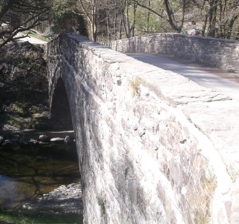
Location: Located 300m S of the main crossroads in Tregeiriog, and carrying the lane to Rhiwlas over the River Ceiriog.

County: Wrexham

Community: Ceiriog Ucha

Community: Ceiriog Ucha

Locality: Tregeiriog

Traditional County: Denbighshire

Tagged with: Bridge Road bridge

Find accommodation in
Llanarmon Dyffryn-Ceiriog

History

Probably C18. One of several bridges of this period which cross the River Ceiriog.

Exterior

Single-span bridge of rubble stone with humped deck. Large segmental-pointed arch of narrow stone voussoirs with dripstone. String course to rubble stone parapets with flat stone copings. Abutments splay out and finish with rectangular end piers at the same level as the parapets. The bridge curves slightly, following the course of the road which crosses the river at an angle.

Reasons for Listing

Listed as a fine C18 bridge of one large span, retaining its character and detail.

External Links

External links are from the relevant listing authority and, where applicable, Wikidata. Wikidata IDs may be related buildings as well as this specific building. If you want to add or update a link, you will need to do so by editing the Wikidata entry.

Recommended Books

Other nearby listed buildings

  • II Milestone to W of Tregeiriog
    Located on the N side of the road on a grass verge, the bank rising steeply behind.
  • II Cart-shed and granary to W of Ty-du Farmhouse
    Located immediately to the W of, and aligned with the farmhouse.
  • II Ty-du
    Set down from the B4500 and reached by a short track, approx 0.7km E of Tregeiriog. Flanked by late C19 outbuildings in the same style.
  • II Service Building to E of Ty-du Farmhouse
    Located immediately to the E of, and aligned with the farmhouse.
  • II Pontricket Farmhouse
    Reached by a short driveway. The farmhouse is built on the slope, with uphill N gable-end towards the road and entrance facing E.
  • II Pont Ricket
    The bridge carries a narrow lane which runs S from the B4500 over the River Ceiriog. It is approx 150m from the main road.
  • II Hafod Adams
    Located on the W side of a lane which runs N from the B4500, between Tregeiriog and Llanarmon Dyffryn Ceiriog. The entrance faces W, away from the road.
  • II Secondary Dwelling at Hafod Adams
    Located immediately to the W of Harod Adams Farmhouse. The W elevation overlooks the Nant Caledwynt, whilst the E side faces the farmhouse.

BritishListedBuildings.co.uk is an independent online resource and is not associated with any government department. All government data published here is used under licence. Please do not contact BritishListedBuildings.co.uk for any queries related to any individual listed building, planning permission related to listed buildings or the listing process itself.

British Listed Buildings is a Good Stuff website.