Approximate Location Map
Large Map »
Latitude: 51.3804 / 51°22'49"N
Longitude: -2.3584 / 2°21'30"W
OS Eastings: 375149
OS Northings: 164657
OS Grid: ST751646
Mapcode National: GBR 0QH.JJH
Mapcode Global: VH96M.2KJM
Plus Code: 9C3V9JJR+5J
Entry Name: 7-9, North Parade Buildings
Listing Date: 12 June 1950
Last Amended: 15 October 2010
Grade: II
Source: Historic England
Source ID: 1395819
English Heritage Legacy ID: 511227
ID on this website: 101395819
Location: Bath, Bath and North East Somerset, Somerset, BA1
County: Bath and North East Somerset
Parish: Non Civil Parish
Built-Up Area: Bath
Traditional County: Somerset
Lieutenancy Area (Ceremonial County): Somerset
Tagged with: Building
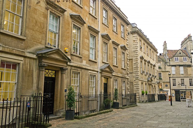
NORTH PARADE BUILDINGS
(West side)
Nos.7-9 (Consec)
12/06/50
GV II
Houses, now offices. 1753. Probably by Thomas Jelly.
MATERIALS: Limestone ashlar with pantile roofs.
PLAN: Double depth plan. No.7 five-bays with central entrance, Nos 8 and 9 are three bays with entrance to left.
EXTERIOR: Three storeys, attic and basement. Quoins to ends of block, platband at first floor level. Entrance doorways have Corinthian columns (Nos 7 and 8) or pilasters (No.9, mid C19 addition as photograph in Ison 66a, shows plain doorway), with pediments, six-panel doors with raised and fielded panels and rectangular light over. Windows on first floor have alternate triangular pediments and straight cornices. All windows have architraves, six/six sashes of late C18 type, including ones in basements except for Nos 8 and 9, which have original sashes. Wrought iron area railings. Dentil cornice, mansard roof with two flat topped dormers to each house, ashlar stacks with pots. Return elevation rubble with modern features.
INTERIORS: Not inspected, but No.7 is said to have fine oak and mahogany staircase in well visible from top to bottom.
HISTORY: These Houses do not appear on Kingston Estate map of 1750, which shows `a garden granted to William Galloway' on this site. Galloway, an apothecary, began building 8 houses on this land in 1750, on land he had held since 1738. Wood probably approved the designs. They were `new built¿ in 1753. SOURCES: Ison W: The Georgian Buildings of Bath: London: 1948-: 149; Holland E: The Kingston Estate within the walled City of Bath: Bath: 1992-; Mowl & Earnshaw, `John Wood. Architect of Obsession¿ (1988), 149.
Listing NGR: ST7514964657
External links are from the relevant listing authority and, where applicable, Wikidata. Wikidata IDs may be related buildings as well as this specific building. If you want to add or update a link, you will need to do so by editing the Wikidata entry.


Other nearby listed buildings
