Approximate Location Map
Large Map »
Latitude: 53.4088 / 53°24'31"N
Longitude: -2.9873 / 2°59'14"W
OS Eastings: 334467
OS Northings: 390678
OS Grid: SJ344906
Mapcode National: GBR 73N.T0
Mapcode Global: WH877.2LR2
Plus Code: 9C5VC257+G3
Entry Name: 10, Hockenhall Alley
Listing Date: 17 December 2008
Grade: II
Source: Historic England
Source ID: 1393065
English Heritage Legacy ID: 504670
ID on this website: 101393065
Location: Liverpool, Merseyside, L2
County: Liverpool
Electoral Ward/Division: Central
Parish: Non Civil Parish
Built-Up Area: Liverpool
Traditional County: Lancashire
Lieutenancy Area (Ceremonial County): Merseyside
Church of England Parish: Liverpool Our Lady and St Nicholas
Church of England Diocese: Liverpool
Tagged with: Building
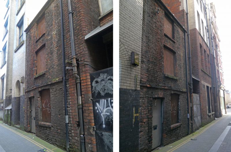
392/0/10334 HOCKENHALL ALLEY
17-DEC-08 10
II
Modest house, originally formed part of a row, late C18/early C19, brick, irregular bond, slate roof, 3 storeys, 1 bay wide
EXTERIOR: Flanked by two tall late C19 warehouses. Doorway with later metal door to ground floor left, boarded over window to right. Boarded over windows to centre of each floor above; that to second floor retains a multipaned lower sash, lower sash survives to ground floor with later plain glazing. First floor window also boarded over internally. Segmental arched heads to door and windows, brick sills to windows. Projecting stringcourse between ground and first floor. Plain rear elevation with off-centre doorway (door removed) to ground floor, later inserted square vent to first floor. Small rear yard area enclosed by walls of surrounding buildings.
INTERIOR: Exceptionally modest with one small room to each floor. Lath and plaster ceilings. Timber winder stair to rear right corner with rope handrail attached to slender central post, under-stair cupboard to ground floor with plank and batten door. Later door off stair at first floor level. Timber partition wall to far right of first floor room creating separate narrow space containing a sink.
HISTORY: Hockenhall Alley was originally known as Molyneaux Weint and lies off one of the oldest roads in the city, Dale Street. Dale Street was the only access route into and out of the city from London and Manchester until the C18, and was the economic and commercial hub of the developing port during the C18 & C19. No.10 Hockenhall Alley is believed to have originally formed part of a short row of houses situated towards the SE end of the alley. 'Hockenhall' was taken from the name of an old Cheshire family. The alley and buildings are not depicted on a map dating to 1729 and the area appears to be enclosed fields with development spreading up from the docks to the SW. The SE section of the alley is depicted as being built up on a map dating to 1765, although in common with C18 maps, individual properties are not marked. It is not known when the other houses in the row were demolished but it was probably at the time of construction of no.10's current neighbouring properties, which are late C19 in date. Another row of similar dwellings further along the alley to the NW was demolished approximately 40 years ago.
SOURCES:
Liverpool City Archives - Historic OS maps
Stonehouse J. 2002. The Streets of Liverpool (first published in 1869). Liverpool Libraries & Information Services.
REASONS FOR DESIGNATION: No.10 Hockenhall Alley is designated at grade II for the following principal reasons:
* It is a rare and important survival of an exceptionally modest working class dwelling that illustrates the inner-city living conditions of some of the poorest members of late C18/early C19 society
* It retains some original features, such as the narrow timber winder stair, a plank and batten door, and lath and plaster ceilings
10 Hockenhall Alley is designated for the following principal reasons:
* It is a rare and intact survival of an exceptionally modest working class dwelling that illustrates the inner-city living conditions of some of the poorest members of late C18/early C19 society
* It retains some original features, such as the narrow timber winder stair, a plank and batten door, and lath and plaster ceilings
External links are from the relevant listing authority and, where applicable, Wikidata. Wikidata IDs may be related buildings as well as this specific building. If you want to add or update a link, you will need to do so by editing the Wikidata entry.


Other nearby listed buildings
