Approximate Location Map
Large Map »
Latitude: 51.4681 / 51°28'5"N
Longitude: -0.0694 / 0°4'9"W
OS Eastings: 534198
OS Northings: 176112
OS Grid: TQ341761
Mapcode National: GBR XW.KX
Mapcode Global: VHGR6.RC5F
Plus Code: 9C3XFW9J+67
Entry Name: Girdlers Almshouses
Listing Date: 27 September 1972
Last Amended: 17 September 1998
Grade: II
Source: Historic England
Source ID: 1378478
English Heritage Legacy ID: 470779
ID on this website: 101378478
Location: Peckham, Southwark, London, SE15
County: London
District: Southwark
Electoral Ward/Division: The Lane
Parish: Non Civil Parish
Built-Up Area: Southwark
Traditional County: Surrey
Lieutenancy Area (Ceremonial County): Greater London
Church of England Parish: Peckham All Saints
Church of England Diocese: Southwark
Tagged with: Almshouse
SOUTHWARK
TQ3476 CHOUMERT ROAD
636-1/12/205 (North side)
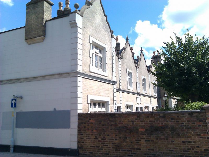
27/09/72 Girdlers' Almshouses: Nos.1-5
(Consecutive)
(Formerly Listed as:
CHOUMERT ROAD
Girdlers' Almshouses)
GV II
Row of 5 almshouses. 1852. By Woodthorpe. Grey brick with
stucco dressings; low pitched slate roof behind frontage of
shaped gables with obelisk finials over each bay.
Unified composition of 2 storeys, 5 bays with projecting end
bays. Rusticated stucco quoins to end bays, with similar
pilaster strips topped with a ball finial dividing the bays.
Stucco squared lintels and alternate block surrounds to doors
and 2- and 3-light mullioned and transomed windows. Plinth and
moulded string at 1st floor. Tall diagonal stacks between each
house.
INTERIOR: not inspected.
Listing NGR: TQ3419876112
External links are from the relevant listing authority and, where applicable, Wikidata. Wikidata IDs may be related buildings as well as this specific building. If you want to add or update a link, you will need to do so by editing the Wikidata entry.


Other nearby listed buildings
