Approximate Location Map
Large Map »
Latitude: 53.743 / 53°44'34"N
Longitude: -0.3363 / 0°20'10"W
OS Eastings: 509823
OS Northings: 428690
OS Grid: TA098286
Mapcode National: GBR GNP.LM
Mapcode Global: WHGFR.T52V
Plus Code: 9C5XPMV7+6F
Entry Name: 16-19 Whitefriargate
Listing Date: 16 June 1971
Last Amended: 17 April 2023
Grade: II
Source: Historic England
Source ID: 1291313
English Heritage Legacy ID: 387840
ID on this website: 101291313
Location: Trinity Court, Kingston upon Hull, East Riding of Yorkshire, HU1
County: City of Kingston upon Hull
Electoral Ward/Division: Myton
Parish: Non Civil Parish
Built-Up Area: Kingston upon Hull
Traditional County: Yorkshire
Lieutenancy Area (Ceremonial County): East Riding of Yorkshire
Church of England Parish: Hull Most Holy and Undivided Trinity
Church of England Diocese: York
Tagged with: Building
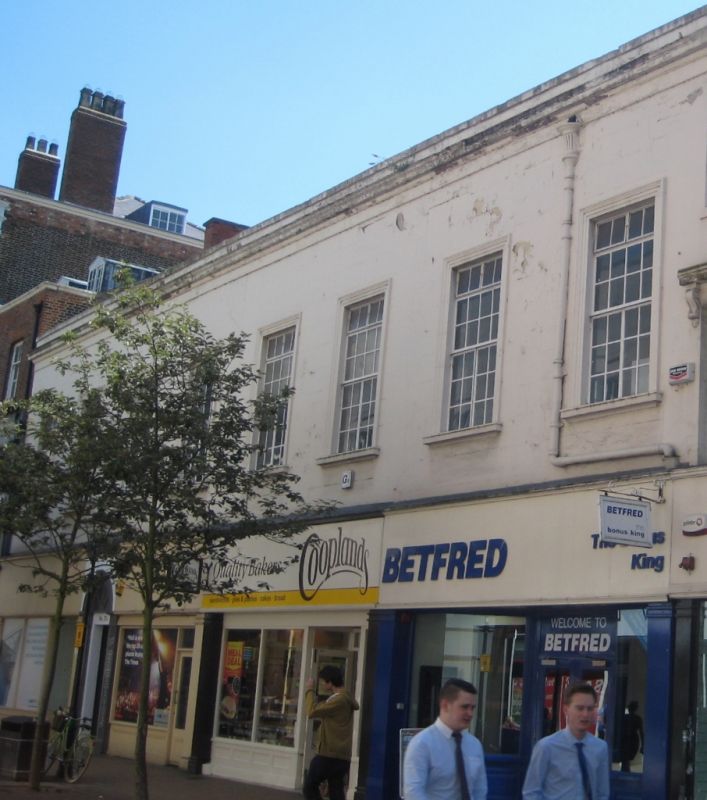
Four mid to late-C18 houses, now shops, with mid- to late-C19 and C20 alterations.
Four mid to late-C18 houses, now shops, with mid- to late-C19 and C20 alterations. Classical style.
(Formerly listed as: WHITEFRIARGATE (South side) Nos.16 AND 17) (Formerly Listed as: WHITEFRIARGATE (South side) Nos.18-20 (Consecutive))
MATERIALS: painted stucco, red brick, slate roof.
PLAN: an east-west aligned building. Polygonal on plan
EXTERIOR: information provided from photographic sources. The building contains four shops (formerly part of a block of five shops with 20 Whitefriargate). The two-storey main (north) elevation has a symmetrical eight-bay street frontage, with a pitched roof and a moulded eaves cornice and blocking. The ground-floor has a moulded C20 cornice, with four late-C20 shop fronts and a doorway (number 17A) between the eastern pair of shop-fronts. The doorway is decorated with late-C20 wooden pilaster jambs supporting a keystone arch, with a fan-light set above a recessed porch with a marble floor and single-panel woode door with multi-paned overlight. The first-floor has stucco inscribed to represent ashlar and eight tall C20 moulded windows surrounds with projecting sills and C20 metal glazing bar casements.
The buildings are located on the south side of Whitefriargate on land owned by Hull Trinity House, a religious guild (established 1369) which became a mariners’ guild in the mid-C15 and whose estate covers the majority of the former site of the Whitefriars (a Carmelite friary, founded in 1122 in Syria and established in Hull by around 1289). Hull Trinity House was originally tenant of the Carmelites whose estate extended east from Trinity House Lane and north to south from Whitefriargate to Posterngate. With the dissolution of the monastery in 1536, it transferred through several hands until Alderman Thomas Ferries transferred what remained (known as the Ferries Estate) to Hull Trinity House mariners’ guild in 1621, before his death in 1631. Hull Trinity House began to let out land on building leases, starting with the corner of Trinity House Lane and Whitefriargate, and there was an on-going renewal of buildings in the estate with properties selected for redevelopment when their income would show the greatest improvement in financial returns.
Numbers 16 to 20 were erected as one 15-bay two-storey building of five houses in the mid to late-C18, at a time when Hull Trinity House began developing major construction schemes for blocks of houses on the south side of Whitefriargate. John Greenwood's 1835 book - Picture of Hull - contains an engraving of the street looking from the north-east which shows this building as three-storey brick built residences. The buildings were in use as both shops and houses by the early-C19. A Webster and F Bancroft, a millinery and dress-rooms, occupied 17 Whitefriargate in 1814, whilst William Bunney, a ship owner and elder brethren warden of Trinity House, occupied number 19. In the mid-C19 the buildings were fully adapted as shops, with stores and amenities to the rear, and it became known as Rutland House.
Between the mid to late-C19 the building was re-fenestrated and rendered. The front elevation was designed with an alternating Palladian arrangement of triple bays in two window styles across the first-floor: one triple bay with pediment and cornices to first-floor windows and another triple bay with plain window surrounds. The second-floor windows all had plain window surrounds. An undated photographic advertisement for grocers S. Lambert and Company (established at number 19 between 1838 and 1960) and Frederick Schultz Smith’s 1880s drawing of Whitefriargate show the fenestrative arrangement for 16 to 19 Whitefriargate matching those of number 20, with symmetrically arranged cornices and pediments to the first-floor windows and ground-floor shops. The fenestrative arrangement for numbers 16 to 19, and the internal floor-plan, was altered again in the the 1920s with the removal of the second-floor to create a double height first-floor and the insertion of eight large symmetrically arranged windows looking onto Whitefriargate. Numbers 16 to 20 are shown as a block of five shops up until the 1955 Goad Insurance Plan and were listed separately in 1971.
16-19 Whitefriargate, Hull, is listed at Grade II for the following principal reasons:
Architectural interest:
* as one of the symmetrical, classically-designed blocks of houses originally built for Hull Trinity House in the mid-late C18, used as shops and houses from the early C19.
Historic interest:
* the building stands on the south side of Whitefriargate where the majority of buildings were constructed in the late C18 and early C19 to provide Trinity House with a rental income from their Whitefriargate estate in addition to their shipping revenues;
* the building has strong group value due to close proximity with a number of carefully planned listed buildings, including the Grade II* former Neptune Inn, which visually enhance and impart character to the historic streetscape of Whitefriargate, one of the main streets in Hull Old Town.
External links are from the relevant listing authority and, where applicable, Wikidata. Wikidata IDs may be related buildings as well as this specific building. If you want to add or update a link, you will need to do so by editing the Wikidata entry.


Other nearby listed buildings
