Approximate Location Map
Large Map »
Latitude: 51.9997 / 51°59'58"N
Longitude: -2.2321 / 2°13'55"W
OS Eastings: 384163
OS Northings: 233495
OS Grid: SO841334
Mapcode National: GBR 1JG.LHF
Mapcode Global: VH93L.8ZBY
Plus Code: 9C3VXQX9+V5
Entry Name: The Old Forge
Listing Date: 30 May 1984
Grade: II
Source: Historic England
Source ID: 1238867
English Heritage Legacy ID: 416521
ID on this website: 101238867
Location: Long Green, Malvern Hills, Worcestershire, GL19
County: Worcestershire
District: Malvern Hills
Civil Parish: Longdon
Traditional County: Worcestershire
Lieutenancy Area (Ceremonial County): Worcestershire
Church of England Parish: Longdon
Church of England Diocese: Worcester
Tagged with: Smithy
SO 83 SW LONGDON LONG GREEN
3/19
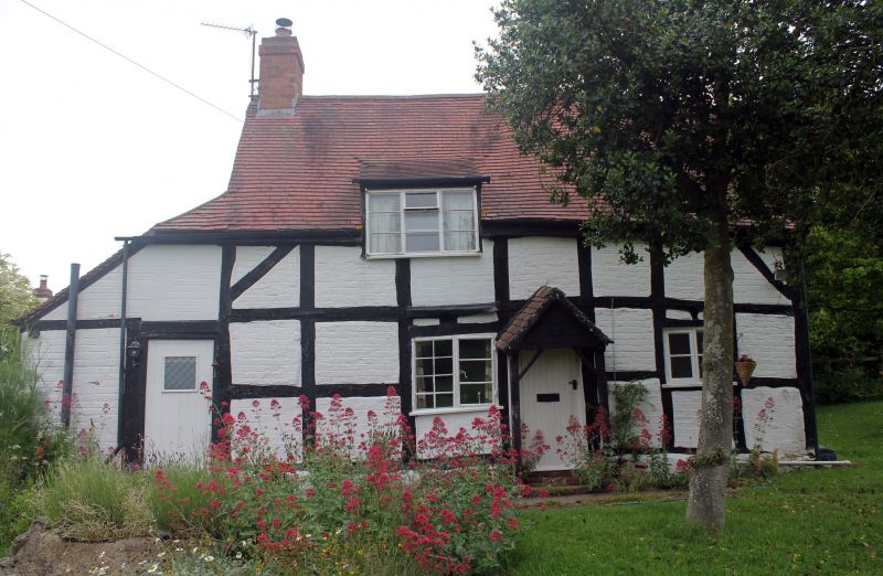
The Old Forge
II
Cottage C17 timber-frame with plain tile roof and West end stack. One storey and
attic with sloping 3-light dormer. Door in porch with iron 2-light casement each
side. West end lean-to with door. Square framed, 3 x 7 panels.
Listing NGR: SO8416333495
External links are from the relevant listing authority and, where applicable, Wikidata. Wikidata IDs may be related buildings as well as this specific building. If you want to add or update a link, you will need to do so by editing the Wikidata entry.


Other nearby listed buildings
