Approximate Location Map
Large Map »
Latitude: 50.2088 / 50°12'31"N
Longitude: -5.2523 / 5°15'8"W
OS Eastings: 168041
OS Northings: 39376
OS Grid: SW680393
Mapcode National: GBR Z2.3WZP
Mapcode Global: VH12Q.X06Q
Plus Code: 9C2P6P5X+G3
Entry Name: Compressor House Approximately 7 Metres West of Pump Engine House to Marriott's Shaft on South Wheal Frances Sett
Listing Date: 12 September 1989
Grade: II
Source: Historic England
Source ID: 1160611
English Heritage Legacy ID: 66704
ID on this website: 101160611
Location: Treskillard, Cornwall, TR16
County: Cornwall
Civil Parish: Carn Brea
Traditional County: Cornwall
Lieutenancy Area (Ceremonial County): Cornwall
Church of England Parish: Redruth
Church of England Diocese: Truro
Tagged with: Architectural structure
CARN BREA PIECE
SW 63 NE
8/155 Compressor house approx. 7
metres west of pump engine house
to Marriott's shaft on
South Wheal Frances sett
GV II
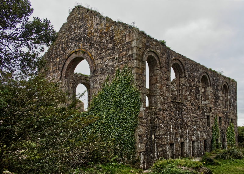
Compressor house to former tin mine, now derelict. Late 1890's, for South
Frances United Mine. Uncoursed granite rubble with quoins, brick arches to
openings; now roofless. Rectangular plan, 3x2 bays, on north-south axis. Two
storeys, with round-headed windows at 1st floor; the west side has a square-
headed doorway up 4 steps near the left (north) end, 7 small rectangular
openings at ground level (tunnels or conduits which pierce the foundations
laterally), and 3 large windows at 1st floor; the opposite side is similar except
for the doorway, and the gable walls have square-headed windows at ground
floor, round-headed above, and small circular windows at the apex. Interior: solid
concrete plinth to 1st floor level, with central cut-out and central fly-wheel
recess. History: formerly contained cross-compound 2-stage plant by Fraser and
Chalmers, capable of working 30 rock drills. Reference: Palmer & Neaverson,
op.cit.
Part of a very impressive group of remains of one of the best equipped mines in
Cornwall, closed in 1918.
Listing NGR: SW6804139376
External links are from the relevant listing authority and, where applicable, Wikidata. Wikidata IDs may be related buildings as well as this specific building. If you want to add or update a link, you will need to do so by editing the Wikidata entry.


Other nearby listed buildings
