Approximate Location Map
Large Map »
Latitude: 51.3196 / 51°19'10"N
Longitude: 0.1667 / 0°10'0"E
OS Eastings: 551081
OS Northings: 160064
OS Grid: TQ510600
Mapcode National: GBR S7.QPB
Mapcode Global: VHHPK.T3Z6
Plus Code: 9F328598+VM
Entry Name: Sepham Court
Listing Date: 16 January 1975
Last Amended: 20 September 1976
Grade: II
Source: Historic England
Source ID: 1243842
English Heritage Legacy ID: 447989
ID on this website: 101243842
Location: Twitton, Sevenoaks, Kent, TN14
County: Kent
District: Sevenoaks
Civil Parish: Shoreham
Traditional County: Kent
Lieutenancy Area (Ceremonial County): Kent
Church of England Parish: Shoreham St Peter and St Paul
Church of England Diocese: Rochester
Tagged with: Hall house
1.
5280 SHOREHAM SHOREHAM
Filston Lane
(East Side)
Sepham Farmhouse
TQ 56 SW 38/1187
II
2.
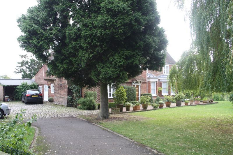
Late mediaeval hall house with alterations. Main entrance front of 2 storeys
and attic, 4 bays. The 2 left bays project under hipped gables of differing
heights. High pitched tiled roofs, hipped at right. Tile hung 1st floor brick
below. 2 right bays of C18 appearance with moulded wood eaves cornice. 2
hipped dormers above. Mid C19 casement windows except for 2 late C19 canted bays in
right part. Rendered east wall. Roof sweeps low behind. At west end large offset
chimney with tumbled brickwork. Jettied 1st floor with visible beam ends, to left
part. Inside much very heavy exposed timber; and crown post in attic. The farm
is named from John de Cepham who owned the manor in the reigh of Edward III.
Sepham Farmhouse shall be amended to read Sepham Court.
------------------------------------
1.
5280 SHOREHAM SHOREHAM
Filston Lane
(East Side)
Sepham Farmhouse
TQ 56 SW 38/1187
II
2.
Late mediaeval hall house with alterations. Main entrance front of 2 storeys
and attic, 4 bays. The 2 left bays project under hipped gables of differing
heights. High pitched tiled roofs, hipped at right. Tile hung 1st floor,
brick below. 2 right bays of C18 appearance with moulded wood eaves cornice.
2 hipped dormers above. Mid C19 casement windows except for"2 late C19 canted
bays in right part. Rendered east wall. Roof sweeps low behind. At west end
large offset chimney with tumbled brickwork. Jettied 1st floor with visible
beam ends, to left part. Inside much very heavy exposed timber; and crown post
in attic. The farm is named from John de Cepham who owned the manor in the
reign of Edward III.
Listing NGR: TQ5108160064
External links are from the relevant listing authority and, where applicable, Wikidata. Wikidata IDs may be related buildings as well as this specific building. If you want to add or update a link, you will need to do so by editing the Wikidata entry.


Other nearby listed buildings
